Iceland photographs as a gateway to Arctic travel
Iceland photographs offer one of the most accessible paths into Arctic travel. When you study these images, you begin to understand how iceland functions as both a destination and a visual laboratory for polar journeys. Each frame of water, ice, and black volcanic rock quietly prepares you for harsher expeditions further north.
The Reykjavík Museum of Photography preserves about five million photographs by professional and amateur photographers, from around 1870 to the present century. This immense archive of images from reykjavik iceland and the wider countryside shows how photographers have long treated every waterfall, glacier, and sand beach as material for serious visual storytelling. For modern travelers, these historic photos and contemporary iceland photographs together form a practical guide to light, weather, and terrain in northern regions.
Many visitors now plan an Arctic itinerary around specific locations that have become icons in photos. The snaefellsnes peninsula, the ice cave systems beneath a glacier, and the famous black sand of diamond beach all appear repeatedly in both amateur photos and professional images from NordicPhotos. By comparing different photos and aerial views of the same waterfall iceland landscapes, you learn how seasons, time of day, and shifting northern lights transform a single scene.
Notable Icelandic photographers help bridge travel and visual culture for anyone curious about polar environments. Ragnar Axelsson (RAX) is known for capturing the lives of people in the Arctic; worked for Morgunblaðið from 1974 to 2020, and his work often links iceland highlands communities with Greenland and other northern territories. When you look at his black and white photos of winter storms, mountain farms, and sea ice, you gain a deeper respect for the realities behind beautiful iceland photographs.
Waterfalls, canyons, and the choreography of Icelandic light
For many travelers, the first serious iceland photographs focus on a waterfall or canyon. The country’s hydrology shapes both the landscape and the visual rhythm of a journey through iceland, especially when you move from southern iceland to the more remote interior. Long exposure photos of water tumbling over black volcanic cliffs reveal how light, spray, and wind interact in constantly changing patterns.
Skogafoss waterfall is a natural classroom for understanding this choreography of light and water. On a bright day, the spray can create multiple rainbows, while in winter the surrounding ice forms delicate textures that reward careful composition and patient timing. When you compare photos of skogafoss waterfall taken at sunset, in mid day glare, and under a faint aurora, you see how the same waterfall iceland scene can support radically different visual narratives.
Canyon iceland landscapes demand a different approach, especially when you work with aerial photography. From the ground, a canyon feels narrow and enclosed, but an aerial view reveals braided rivers, carved terraces, and subtle color shifts in the water and moss. Many travelers now combine drone images with traditional photos to create layered stories of iceland highlands terrain, where every canyon, glacier, and mountain ridge contributes to a broader Arctic context.
Along the coast, the interplay between sand beach curves and black volcanic cliffs offers another set of visual possibilities. Locations like diamond beach, with its scattered ice fragments, allow you to practice composing foreground, midground, and background before tackling more extreme polar shorelines. For travelers interested in maritime heritage, this visual training also enriches experiences on immersive Bering Sea adventures and the legacy of crab fishing, which you can explore further through an in depth article on Aleutian Ballad immersive Bering Sea adventures and the legacy of crab fishing.
Northern lights, aurora borealis, and winter night photography
Many travelers first consider Arctic and Antarctic journeys after seeing iceland photographs of the northern lights. In iceland, the aurora and aurora borealis displays are frequent enough in winter to allow repeated attempts at refining technique, which is invaluable before committing to more remote polar expeditions. These northern skies become both a subject and a training ground for patience, planning, and respect for weather.
Capturing the aurora requires understanding how winter conditions shape both comfort and camera performance. Temperatures near a glacier lagoon or on the snaefellsnes peninsula can drop quickly, so layering, wind protection, and careful battery management are essential. When you review images of aurora above kirkjufell mountain or over lagoon iceland waters, you can often read the photographer’s decisions about exposure, foreground, and timing in the final photos.
Locations such as kirkjufell iceland and the surrounding sand beach provide classic compositions that combine mountain silhouettes with reflections in still water. On a calm night, the northern lights can arc above kirkjufell, while ice fragments in the lagoon or along a black sand shoreline catch subtle green and purple tones. By studying multiple iceland photographs from these sites, you learn how slight shifts in tripod position or lens choice change the balance between sky, mountain, and water.
Night photography also encourages a slower, more attentive style of travel that suits Arctic and Antarctic environments. Long hours under the aurora borealis invite you to listen to the wind, watch cloud movements, and anticipate gaps that reveal the stars. This habit of close observation, developed while chasing northern lights in southern iceland or near reykjavik iceland, becomes invaluable when you later photograph polar wildlife, sea ice, or remote research stations under equally fragile light.
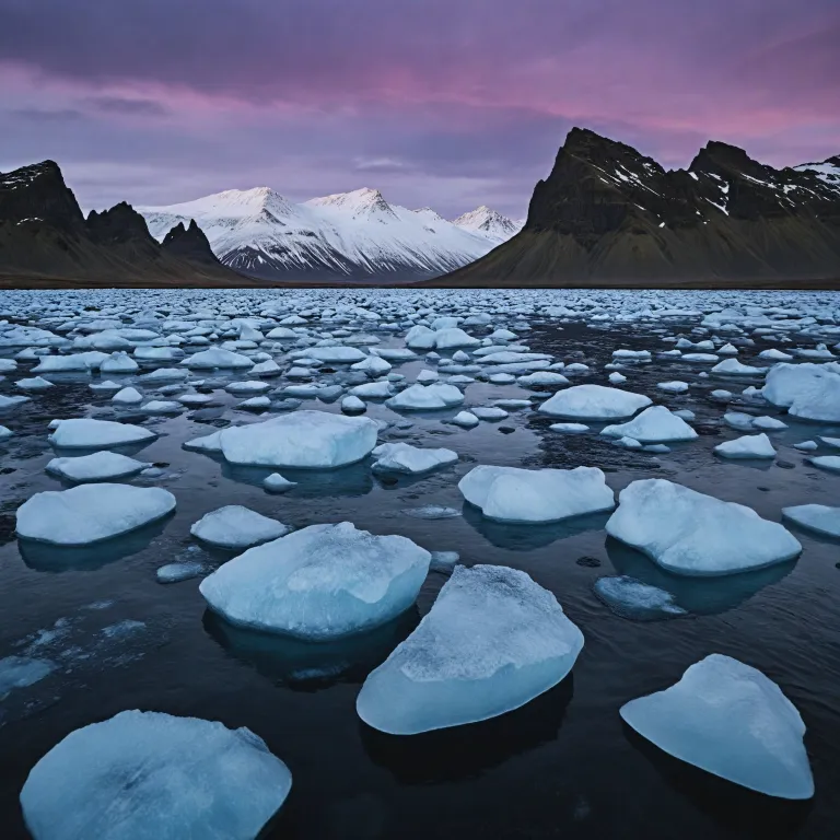
Glaciers, ice caves, and the language of blue
Glacier landscapes dominate many of the most compelling iceland photographs, and they speak directly to the wider polar world. When you walk on a glacier in iceland, you encounter the same crevasses, meltwater channels, and shifting ice that define travel in Greenland or Antarctica. Each photo of ice, water, and sky becomes part of a visual record of climate, time, and human presence.
Ice cave experiences are particularly valuable for travelers interested in understanding polar environments. Inside an ice cave, the filtered light reveals layers of compressed snow, volcanic ash, and trapped air bubbles that tell a geological story. Photographers often experiment with both wide angle images and intimate photos of textures, using the deep blue tones as a natural backdrop for silhouettes or carefully placed beams of day light.
Lagoon iceland locations, where icebergs drift between glacier fronts and the open sea, offer another essential training ground. Here, you can practice composing moving ice against a distant mountain or black volcanic shoreline, adjusting shutter speed to either freeze motion or blur the water’s surface. At nearby diamond beach, the contrast between clear ice and black sand creates a natural studio for studying reflection, refraction, and the subtle color shifts that occur at sunset.
These glacier and lagoon scenes also connect directly to the work of Icelandic photographers who document Arctic communities and landscapes. Ragnar Axelsson’s long term projects, for example, show how ice conditions affect daily life, while Nökkvi Elíasson’s black and white images of deserted farms hint at social changes linked to environmental shifts. When you engage with their photos alongside your own, you begin to see every glacier, ice cave, and lagoon as part of a shared polar narrative rather than isolated iceland photographs.
Coasts, black sand beaches, and whale watching perspectives
The coastline of iceland provides a natural bridge between North Atlantic travel and more remote polar seas. Many travelers first encounter the drama of Arctic waters while standing on a black sand beach, watching heavy surf roll in under a low northern sun. These coastal iceland photographs help you understand how wind, swell, and light interact along high latitude shorelines.
Reynisfjara and other black sand beaches in southern iceland are especially instructive for photographers. The combination of black volcanic sand, white foam, and grey water creates a limited but powerful palette that rewards careful attention to texture and contrast. When you compare images taken on stormy days with photos from calm sunset evenings, you see how quickly mood shifts along this exposed coast.
Whale watching excursions from reykjavik iceland or northern harbors add another dimension to coastal photography. Shooting from a moving boat challenges your sense of timing, composition, and stability, especially in winter when light levels are low. Successful whale watching photos often combine a distant mountain or glacier with the curve of a whale’s back, linking marine life to the broader Arctic landscape in a single frame.
These maritime experiences also connect naturally to the culinary and cultural side of polar travel. Coastal communities in iceland share a deep relationship with fish, seabirds, and the sea itself, themes explored in more detail in this guide to Arctic and Antarctic travel exploring local cuisine and culinary heritage. When you photograph a harbor at day break, a sand beach at low tide, or a lagoon iceland fishing boat at rest, you are not only creating attractive iceland photographs but also documenting the working rhythms that underpin life across the North Atlantic and beyond.
From Reykjavík archives to aerial views of the Icelandic highlands
Reykjavík serves as both a cultural hub and a practical starting point for serious iceland photographs. The Reykjavík Museum of Photography and collections like NordicPhotos together hold more than ten million images, offering a deep visual history of iceland and the wider Arctic region. By spending time with these archives before heading into the field, you gain a clearer sense of how earlier photographers approached the same mountain passes, canyons, and coastal villages you plan to visit.
Aerial photography has transformed how travelers understand the iceland highlands and remote interior. From above, patterns in water channels, lava fields, and glacier tongues become legible in ways that ground level photos cannot match. When you study an aerial view of canyon iceland landscapes or braided rivers cutting through black volcanic plains, you begin to grasp the scale and structure of terrain that once seemed chaotic.
Modern travelers often combine drone images with traditional ground based photos to build layered narratives of a single region. For example, a sequence might begin with an aerial view of kirkjufell mountain, continue with close up photos of water flowing at its base, and end with sunset images from a nearby beach. This approach mirrors the methods used by experienced Arctic photographers, who move between wide context and intimate detail to tell complete stories about ice, land, and people.
Reykjavík also connects you to the work of influential Icelandic photographers whose careers span portraiture, landscape, and documentary projects. Sigríður Zoëga’s relaxed portraits, Rebekka Guðleifsdóttir’s innovative online images, and Nökkvi Elíasson’s stark black and white photos of abandoned farms all contribute to a rich visual culture. When you place your own iceland photographs within this lineage, every glacier, canyon, and northern lights frame becomes part of a broader conversation about how we see and understand the Arctic world.
Planning ethical, climate aware photography journeys in Iceland
Thoughtful iceland photographs can support responsible Arctic and Antarctic travel when they are created with care. As visitor numbers grow, it becomes essential to balance the desire for striking images with respect for fragile ecosystems and local communities across iceland. This balance is particularly important in heavily photographed sites such as diamond beach, lagoon iceland viewpoints, and popular waterfall iceland locations.
Ethical practice begins with simple field decisions that protect both people and landscapes. Staying on marked paths near a glacier or canyon iceland viewpoint reduces erosion and keeps you clear of unstable ground, especially in winter when snow hides hazards. Respecting drone regulations around wildlife, settlements, and sensitive sites ensures that aerial images of iceland highlands or coastal waters do not disturb animals or residents.
Climate awareness also shapes how you plan and share your journeys. Many travelers now choose slower itineraries that spend more days in fewer regions, reducing internal flights while allowing deeper engagement with each mountain valley, sand beach, or ice cave. When you present your photos of northern lights, kirkjufell iceland, or whale watching excursions, adding context about changing ice conditions and local perspectives helps viewers understand the environmental stakes behind the beauty.
Finally, consider how your work might contribute to ongoing documentation of polar regions. Submitting carefully captioned images to local archives, workshops, or institutions in reykjavik iceland helps build a long term record of water levels, glacier retreat, and seasonal patterns. In this way, every thoughtful set of iceland photographs, from aerial views of the snaefellsnes peninsula to intimate photos inside an ice cave, can support both personal memories and collective knowledge about the Arctic and its future.
Key statistics on Icelandic photography and archives
- The Reykjavík Museum of Photography preserves about five million photographs by professional and amateur photographers, from around 1870 to the present century.
- The NordicPhotos collection comprises over five million images created by approximately 300 photographers across the Nordic region.
Questions people also ask about Iceland photographs and Arctic travel
Why is Iceland popular among photographers?
Iceland is popular among photographers because its landscapes combine glaciers, volcanoes, geysers, waterfalls, and dramatic coasts in a relatively compact area. This diversity allows travelers to practice a wide range of techniques, from long exposure waterfall images to aerial views of highland canyons, often within a single trip. The presence of the northern lights, ice caves, and black sand beaches further strengthens its appeal as a gateway to Arctic style photography.
Who are some notable Icelandic photographers?
Notable Icelandic photographers include Ragnar Axelsson, often known as RAX, whose long term projects focus on people and landscapes across the Arctic. Nökkvi Elíasson is recognized for his black and white images of deserted farms and abandoned buildings, while Sigríður Zoëga is celebrated for relaxed, natural portraiture from the early twentieth century. Contemporary photographer Rebekka Guðleifsdóttir gained international attention for her innovative online work and was named the Web's Top Photographer by a major international newspaper.
What are some popular photography locations in Iceland?
Popular photography locations in Iceland include the Golden Circle, where waterfalls and geothermal areas sit within easy reach of Reykjavík. Jökulsárlón Glacier Lagoon and nearby diamond beach attract photographers interested in icebergs, reflections, and black sand compositions. The snaefellsnes peninsula offers a compact mix of mountains, coasts, and small communities, making it ideal for travelers preparing for more remote Arctic or Antarctic journeys.
