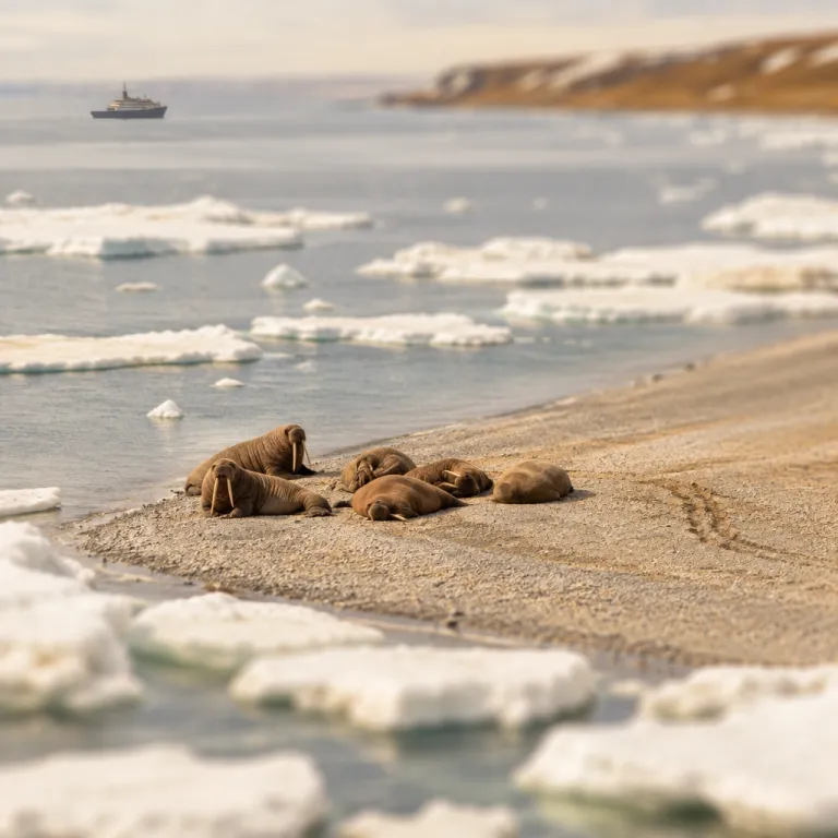
Walrus from space project and why it matters for polar travellers
The walrus from space project is transforming how travellers think about the Arctic. By linking your journey to real conservation work led by WWF and British Antarctic Survey, this initiative turns a classic wildlife cruise into a chance to support science and understand climate change with unusual clarity. It also shows how closely every walrus and every floe of sea ice are tied to the choices we make far from the poles, whether on Facebook, Twitter, LinkedIn or in everyday life at home.
At its core, the project uses very high resolution satellite imagery to count each walrus hauled out on remote shores, across roughly 25 000 square kilometres of Arctic coastline. British Antarctic Survey leads the research, while WWF coordinates public participation and helps explain why melting ice and warming seas are reshaping walrus behaviour. For anyone planning an Arctic voyage, this means your trip can align directly with the same regions and haul out beaches that scientists monitor from space as sea ice melts and reforms year after year.
Citizen scientists act almost like a global walrus detective network, scanning images from space and marking each animal they see on snow, rock, or ice. These walrus detectives work from laptops and tablets, while field teams validate the counts with drones and ground surveys along the sea edge. When you stand on deck watching walruses from a respectful distance, you are looking at the same animals that appear as tiny cinnamon dots in satellite imagery captured from hundreds of kilometres above, linking your experience to data that will inform conservation for years.
How satellite imagery and citizen science track walruses from orbit
For travellers used to binoculars and camera lenses, the leap to satellite imagery can feel dramatic. Yet the same curiosity that draws you to a walrus colony also powers the walrus from space project, where anybody with internet access can help count animals. This blend of tourism awareness and citizen science is one of the most powerful new tools for understanding climate change in the Arctic and how sea ice loss affects wildlife behaviour.
Maxar Technologies supplies the satellite data, while the GeoHive platform turns each image into a simple interface where you can click every walrus you spot. The British Antarctic Survey team then compares these citizen counts with data from drones and ground expeditions, refining algorithms that will one day scan thousands of kilometres of sea ice automatically. As WWF and the wider scientific équipe emphasise, this non invasive approach avoids disturbing young calves and stressed adults when sea ice melts early or storms push them ashore onto narrow strips of snow covered coastline.
When you later travel north by expedition ship, you can visit the same Atlantic and Laptev walrus haul outs that you once saw only from space. Guides now explain how walruses from different regions respond as ice melts earlier in the season and snow cover shrinks along the coast. If you are already interested in food webs, you can deepen that knowledge by reading about what the Arctic cod really eats and why it matters for polar travelers at this detailed Arctic cod guide, which many operators now highlight in their main content for guests who want more context.
Sea ice, climate change and what travellers will actually see
Every traveller now hears about climate change, but the walrus from space project shows what it looks like in practice. Walruses rely on sea ice as a resting platform between feeding dives, and as seasonal ice melts earlier they are forced to haul out on land in larger, denser groups. That shift increases the risk of deadly stampedes, especially when young animals panic at noise or sudden movement and rush across snow or shingle.
Satellite imagery reveals how the pattern of sea ice loss is not uniform across the Arctic, with some regions losing summer sea ice at around 12 percent per decade while others change more slowly. From a ship, you will notice patchier ice, more open water, and sometimes large herds of walruses from different age classes crowded on narrow beaches. Guides now use maps derived from the walrus from space project to explain why one bay holds animals while another, once reliable, now lies empty as the climate warms and sea conditions shift.
For travellers, this means your itinerary is no longer just about scenery but about witnessing a living climate archive written in snow, ice, and sea. You may hear staff discuss how counts from space and from ground surveys help identify critical haul out sites that require stricter approach distances. When you photograph a walrus from a Zodiac, you are capturing a moment in a long series of images that, over years, will show how far the ice edge has retreated and how climate change reshapes the Arctic seascape.
Becoming a walrus detective before and after your voyage
One of the most engaging aspects for travellers is the chance to become a walrus detective yourself. Before you sail, you can join the online platform and practise identifying walruses from above, learning how their shapes differ from rocks, shadows, or patches of melting snow. This training sharpens your eye for detail, which later helps you read real landscapes from the ship’s rail and understand how sea ice and snow patterns influence where animals rest.
Project organisers describe the process in simple terms ; “Anybody with internet access; under-13s need parental consent” can participate as a walrus detective. That accessibility means families can involve young travellers long before they reach the Arctic, turning pre departure evenings into shared wildlife sleuthing sessions. During the voyage, expedition staff often run informal workshops that compare your earlier satellite clicks with live views of walruses from the observation deck, sometimes sharing stories from WWF British Antarctic colleagues who use similar tools further south.
After you return home, you can continue contributing counts from space, keeping a personal connection to the coastline you visited. Over years, your repeated efforts help scientists track how often specific beaches fill with animals and how those patterns shift as sea ice retreats. This continuity between online activity and on board experience is one reason many operators now highlight the walrus from space project in their main content rather than treating it as a side note, and why some even invite you to stay in touch via Twitter, LinkedIn or email newsletters.
Planning ethical walrus encounters in a rapidly changing Arctic
Responsible operators now design itineraries around data emerging from the walrus from space project. By knowing which haul outs are most sensitive, they can time visits to minimise disturbance and maintain generous stand off distances for ships and Zodiacs. Travellers who care about ethics should ask how a company uses satellite imagery and ground research when planning wildlife encounters, and whether they collaborate with WWF or British Antarctic Survey scientists.
On board, briefings increasingly explain how climate change and sea ice loss affect walrus stress levels, especially when large groups of walruses from multiple age classes crowd together. Guides emphasise quiet behaviour, limited Zodiac numbers, and strict rules about not approaching animals on the ground or on low ice pans. If you are keen on photography, you can study best practice for long lens work from small boats at resources such as this guide to photographing polar bears from a Zodiac, which also applies to walrus viewing, available at this Zodiac photography article that many travellers now bookmark before they sail.
Ethical travel also extends to how you share your experience once home, whether on Facebook, Twitter, LinkedIn, or more specialised wildlife forums. When posting images of walruses from your trip, consider adding context about sea ice loss and the role of satellite imagery in monitoring populations. That way, each photograph becomes part of a wider conversation about why this species, and the Arctic sea it inhabits, needs careful stewardship and how individual choices contribute to climate solutions.
What this means for Antarctic travellers and polar wide perspectives
Although walruses live in the Arctic rather than the Antarctic, the methods behind the walrus from space project resonate strongly with southern polar travel. British Antarctic Survey scientists who refine satellite techniques for walrus counts also apply similar tools to penguins, seals, and even krill dependent ecosystems. For travellers heading south, this means your Antarctic voyage benefits from the same advances in remote sensing and citizen science pioneered in the north, including lessons about how sea ice change affects wildlife.
When you hear about an Antarctic survey of penguin colonies or seal haul outs, you are listening to a cousin of the walrus from space approach. The combination of satellite imagery, drones, and targeted ground checks allows researchers to cover vast coastlines that ships visit only briefly each season. As climate change alters sea ice around both poles, these methods help identify which regions remain refuges and which are under acute pressure, guiding conservation priorities for years to come.
For polar travellers who visit both regions over several years, the contrast can be striking yet instructive. You may see how sea ice around the Antarctic Peninsula thins while some interior shelves remain stable, echoing the patchwork of change seen in Arctic walrus habitat. Understanding this shared story across both poles deepens the meaning of your journeys and reinforces why projects that look at wildlife from space deserve a place in every serious travel conversation, whether you follow updates via NPR, WWF channels, or specialist expedition newsletters.
Key figures from the walrus from space project
- Approximately 25 000 square kilometres of Arctic coastline are covered by high resolution satellite imagery in the project, giving scientists a pan regional view that no single expedition ship could match in one season.
- Summer sea ice in key walrus regions is declining at around 12 percent per decade according to project validation studies, a rate that directly influences how often walruses haul out on land rather than resting on drifting ice.
- The project runs over a planned five year duration, allowing repeated counts that turn one off snapshots into a time series capable of revealing genuine population trends rather than short term fluctuations as the climate continues to change.
- Citizen scientists worldwide contribute thousands of annotated satellite tiles, which are then cross checked against drone and ground surveys to ensure that automated detection models reach the accuracy needed for conservation decisions and future Antarctic survey work.
FAQ about the walrus from space project for travellers
Who can participate as a walrus detective before travelling north ?
Anybody with internet access can join the online platform and start marking walruses in satellite images, although under 13s need parental consent to register and take part in the walrus detective activities, whether they first hear about the project on Facebook, Twitter, LinkedIn or through an operator newsletter.
Which walrus species are included in the satellite counts ?
The project focuses on Atlantic walrus and Laptev walrus populations, because these groups haul out along coastlines that can be imaged clearly from space and are particularly exposed to rapid sea ice loss and other climate change impacts.
How do scientists ensure that citizen science counts are accurate ?
Researchers validate the public’s satellite based counts using drones flown over haul outs and carefully planned ground surveys, then compare results to refine both training materials and automated detection algorithms. Over years, this process builds a robust record that can be compared with other climate and sea ice datasets.
Can my choice of operator influence walrus conservation outcomes ?
Yes, because operators who collaborate with research organisations and respect approach guidelines help reduce disturbance at sensitive haul outs, while also educating guests about how satellite imagery and climate data guide modern conservation policy. Many will share follow up information by email, Twitter, LinkedIn or other channels so you can stay involved.
Does this project have any relevance for Antarctic voyages ?
It does, since the same satellite and drone methods used for walrus monitoring are now being adapted by British Antarctic Survey and partners to map penguin, seal, and other wildlife colonies around the Antarctic coastline. Travellers sometimes even receive updates from specific scientists, such as a field coordinator like Sharon Pruitt Young, via email or expedition blogs that explain how lessons from walruses from space inform wider polar research.